

 Antigua and Barbuda
is a twin-island country in the Americas, lying between the Caribbean Sea and the Atlantic Ocean. It consists of two major inhabited islands, Antigua and Barbuda, and a number of smaller islands (including Great Bird, Green, Guinea, Long, Maiden and York Islands and further south, the island of Redonda). Separated by a few nautical miles, Antigua and Barbuda are in the middle of the Leeward Islands, part of the Lesser Antilles, roughly at 17°N of the equator.
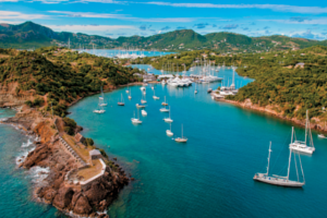
Antigua and Barbuda is a country encompassing its 2 namesake islands and several smaller islands. Positioned where the Atlantic and Caribbean meet, it's known for reef-lined beaches, rainforests and resorts. Antigua's English Harbour is a yachting hub and the site of historic Nelson's Dockyard, now part of a national park. In the capital, St. John's, the national museum displays indigenous and colonial artifacts.
Capital: St. John's
Currency: East Caribbean dollar
Language: English
Population: 89,985(2013)
Climate
The climate is tropical marine with little seasonal temperature variation. The islands experience hurricanes and tropical storms (July to October), and periodic droughts.
Safety
Though Antigua and Barbuda is a very safe place, secure your purses and wallets. Walk only with the necessary money, avoid street urchins and vagrants and don't be afraid to ask for help. If you rent a car, park in a well-lit area.
While in St. John's, be mindful of casino scams. The Keno Palace Casino on St. James street runs a variation on the "Razzle Dazzle" game in which a woman will try to lure you in to the Casino with the promise of free bets. The game they bring you to involves pulling balls out of a hopper, with the ultimate goal being to tally a score over 100. You'll appear to be doing quite well at first, and will be enticed to bet real money to chase the cash pot. Before you know it, you may be out hundreds of dollars chasing a prize that you'll never win. Avoid this scam at all costs.
Getting Around
Tourists mainly get around by taxi or tour operators. However for the tourist on an economy budget the bus service is acceptable, but slow. Unfortunately the nicest spots are only reached by your own transport. But if you stay a week or more, rates for rental cars become quite reasonable.
 Dominica
Dominica officially the Commonwealth of Dominica, is a sovereign island country.[7] The capital, Roseau, is located on the leeward side of the island. It is part of the Windward islands in the Lesser Antilles archipelago of the Caribbean Sea. The island lies south-southeast of Guadeloupe and northwest of Martinique. The island was originally inhabited by the Kalinago and later colonised by the Europeans, predominately by the French from the 1690s, who arrived long after Columbus passed the island on Sunday, 3 November 1493 ("Sunday" = "Dominica" in Latin). Great Britain took it over in 1763 after the Seven Years' War and gradually established English as the official language. The island republic gained independence in 1978.
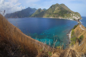
Dominica is a mountainous Caribbean island nation distinguished by geothermal hot springs. Its most famous spring may be the volcanically heated, steam-covered Boiling Lake, which falls within Morne Trois Pitons National Park. This preserve also encompasses rainforest, sulphur vents, the twin waterfalls of Trafalgar Falls and narrow Titou Gorge. To the west is Dominica’s capital, Roseau, with colorful timber houses and botanic gardens.
Capital: Roseau
Currency: East Caribbean dollar
Language: English
Population: 72,003(2013)
Climate
The Eastern Caribbean dollar (EC$) is used and US dollars are widely accepted. Unless rates are posted in US dollars, as is the norm with accommodations, it usually works out better to use EC dollars.
There aren’t many ATMs outside of Roseau and Portsmouth .
Safety
Dominica is one of the safest places to travel in the region.
There are no poisonous snakes or insects in Dominica
Take usual precautions when travelling around Dominica. Although rare, petty crimes are most likely to happen around Roseau. Elsewhere the island is extremely safe.
Swimming in the Atlantic Ocean is not generally recommended because of strong currents. Popular Atlantic beaches are generally safe enough for cautious swimming, but random strips of sand on the Atlantic side are generally subject to extreme undertoes and big waves. As a rule of thumb, swim where the locals swim!
Swimming in rivers is pretty safe. There are no creatures in the rivers that will cause you serious harm, but, as always, there are pests such as leeches. Flash floods, while uncommon, do happen. If you notice the water change color, this may be because of dislodged sediment and thus could be an indicator of an imminent flash flood.
Health
Tap water is safe to drink, but since it is sometimes drawn straight from Dominica's many rivers, it has a tendency to turn brown after heavy rainfall. It's better to drink the bottled water available almost anywhere.
Basic healthcare is available at Princess Margaret Hospital in Roseau.
North Americans moving to Dominica often experience boils for the first time and fingernail and toenail fungi. Stomach problems are rare among travellers.
Towns are sprayed with insecticides periodically to control the mosquitoes responsible for spreading Dengue fever. However, the spraying may not be done at the scheduled time and pesticides may drift into your home if the windows are open.
Getting Around
If you are on a low budget and have plenty of time then the bus will be fine (except on Sundays, or weekdays after the early evening, when the only bus running goes between Portsmouth and Roseau). these buses are generally safe and timely, the local drivers know the roads well and are used to all the usual weather conditions. Buses are owned and operated privately and therefore do not have to adhere to any timetables and come and go whenever they are filled to the driver's satisfaction– ask around for approximate departure and arrival times, but know that they vary day to day.
Taxi is more comfortable than the buses and may not be expensive, particularly if the fare is shared with 2+ travelers. Whether you use the bus or taxi, make sure that you clearly agree to the destination and price before you start the trip.
 Saint Kitts and Nevis
The Federation of Saint Kitts and Nevis, also known as the Federation of Saint Christopher and Nevis, is a two-island country in the West Indies. Located in the Leeward Islands chain of the Lesser Antilles, it is the smallest sovereign state in the Americas, in both area and population. The country is a Commonwealth realm, with the British monarch (currently queen Elizabeth II) as head of state.
Saint Kitts and Nevis were among the first islands in the Caribbean to be settled by Europeans. Saint Kitts was home to the first British and French colonies in the Caribbean, and thus has also been titled "The Mother Colony of the West Indies."
It's known for cloud-shrouded mountains and beaches. Many of its former sugar plantations are now inns or atmospheric ruins. The larger of the 2 islands, Saint Kitts, is dominated by the dormant Mount Liamuiga volcano, home to a crater lake, green vervet monkeys and rainforest crisscrossed with hiking trails.
Capital: Oranjestad
Currency: East Caribbean dollar
Language: English
Population: 54,191(2013)
Climate
Tropical tempered by constant sea breezes; little seasonal temperature variation; rainy season (May to November).
Safety
The Mount Liamuiga hiking excursion offered by many cruise ship lines involves some climbing, at times necessitating the scaling of rocks by hand. To reach the last lookout, you have to grab onto a rope and hoist yourself onto a rock ledge and climbing over large fallen trees.
The trails are not marked, and consist of little more than a space between two trees, or two rocks and can be muddy, there is little shelter from the rain, and no toilets.
 Anguilla
Anguilla is a British overseas territory in the Caribbean. It is one of the most northerly of the Leeward Islands in the Lesser Antilles, lying east of Puerto Rico and the Virgin Islands and directly north of Saint Martin. The territory consists of the main island of Anguilla, approximately 16 miles (26 km) long by 3 miles (5 km) wide at its widest point, together with a number of much smaller islands and cays with no permanent population.
Anguilla has become a popular tax haven, having no capital gains, estate, profit or other forms of direct taxation on either individuals or corporations. In April 2011, faced with a mounting deficit, it introduced a 3{30b3c1a05441a6ec696a3ef2bf35d9a34dfa377050be22c8a6500787eb0a1c7f} "Interim Stabilisation Levy", Anguilla's first form of income tax.
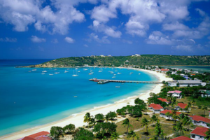
Its beaches range from long sandy stretches like Rendezvous Bay, overlooking neighboring Saint Martin Island, to secluded coves reached by boat, such as at Little Bay. Protected areas include Big Spring, known for its prehistoric petroglyphs, and East End Pond, a wildlife conservation site.
Capital: The Valley
Currency: East Caribbean dollar
Language: English
Population: 15,094 (2011)
Climate
Northeastern trade winds keep this tropical island relatively cool and dry. Average annual temperature is 80 °F (27 °C). July–October is its hottest period, December–February, its coolest.
Safety
Anguilla is a safe island with a low crime rate. But please take necessary precautions: lock your doors at night, don't leave personal belongings in your unlocked rental car and don't give rides to pedestrians.
The police station is in the capital, The Valley, as well as the hospital, Princess Alexandra Hospital. There is only one hospital in Anguilla, however there are many private doctors, including Hughes Medical Center located in West End. There are many medical clinics located in many villages such as The Valley, West End, East End and Blowing Point.
Getting around
Driving is on the left-hand side of the road. Speeds are low, but the island is small. There are also a few round-abouts and stop lights throughout the island. Keep left and Give way to the right!
Taxi service is unmetered, with set rates. Taxi drivers offer island tours lasting several hours. Fares must be paid in cash and or credit card.
The ferry from Blowing Point to Marigot, St. Martin runs all day on the half hour. The last ferry departs Anguilla at 6:15PM and final ferry departs St. Martin at 7:00PM. Connections and charters are available to other islands.
Cars, bikes, and mopeds can all be rented. Rental cars are available in from several different agencies. Hertz, Avis and other local agencies.
 Saint-Barthélemy
Saint-Barthélemy, officially the Territorial collectivity of Saint-Barthélemy, is an overseas collectivity of France in the West Indies. Often abbreviated to Saint-Barth in French, or St. Barts or St. Barths in English, the indigenous people called the island Ouanalao. St. Barthélemy lies about 35 kilometres (22 mi) southeast of St. Martin and north of St. Kitts. Puerto Rico is 240 kilometres (150 mi) to the west in the Greater Antilles. Saint Barthélemy was for many years a French commune forming part of Guadeloupe, which is an overseas region and department of France. In 2003, the island voted in favour of secession from Guadeloupe in order to form a separate overseas collectivity (COM) of France. Saint Barthélemy, a volcanic island fully encircled by shallow reefs.
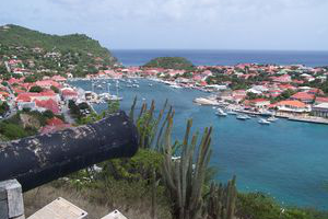
It is known for its white-sand beaches, chic hotels and designer shops. The capital, Gustavia, encircling a yacht-filled harbor, combines high-end dining with historical attractions like The Wall House, whose exhibits highlight the island’s Swedish colonial era. Perched above town is 17th-century Fort Karl, offering views of popular Shell Beach.
Capital: Gustavia, Saint Barthélemy
Currency: Euro
Language: French
Population: 9,035 (Jan 2014)
Climate
The eastern side is wetter than the western. Although the climate is essentially arid, the rainfall does average 1000 mm annually, but with considerable variation over the terrain. Summer is from May to November, which is also the rainy season. Winter from December to April is the dry season. Sunshine is very prominent for nearly the entire year and even during the rainy season. Humidity, however, is not very high due to the winds.
Safety
St Barths is without a doubt the safest island in the Caribbean, and one of the safest places in the world. There is virtually zero crime, beyond petty theft. You can go anywhere on the island night or day with no fear whatsoever for your personal safety. However do not leave valuables in your car, and use the safe in your villa or hotel. There are no pickpockets, muggers, dealers or street traders to hassle you. The roads are narrow and often steep and winding. Small 4x4 rental jeeps are the vehicle of preference and renting scooters is not advised.
 Montserrat
Montserrat is a Caribbean island—specifically in the Leeward Islands, which is part of the chain known as the Lesser Antilles, in the British West Indies. It is a British Overseas Territory (BOT). Montserrat is nicknamed The Emerald Isle of the Caribbean both for its resemblance to coastal Ireland and for the Irish ancestry of many of its inhabitants.
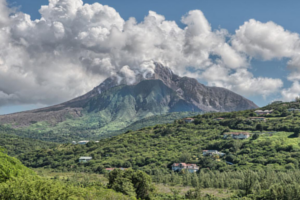
Its Soufrière Hills volcano erupted in the 1990s, causing significant damage to the south of the island and leading to the creation of an exclusion zone. The north of the island is largely unaffected, and has black-sand beaches, coral reefs, cliffs and shoreline caves.
Capital: Little Bay, Montserrat, Brades, Plymouth
Currency: East Caribbean dollar
Language: English
Population: : 4,900(2012)
Climate
Temperatures year-around average between 76-88°F (24-32°C), with constant cooling breezes. Rainfall is a little more common from July to November.
Safety
Montserrat is generally a safe place. However in recent years, violent crime has increased. Assault is the most common form, with an annual rate of just over 10 assaults for every 1000 people. General safety precautions, including such as not walking in an alleyway at night, are advised. The island is still vulnerable to hurricanes during the season from June to November.
Health
No vaccinations are required to enter Montserrat unless coming from a country that has suffered a cholera, yellow fever, or small pox epidemic.
Getting Around
Montserrat has one main road that winds along the coast on the east and west sides of the island. Cars can be rented from any of a number of agencies. Traffic is mild (there are no traffic lights to bother with), but be warned that there are only two gas/petrol stations on the island.
A temporary Montserrat driver's license is required to drive on the island.
Bicycle rentals are also available.
Taxis and minibuses run mostly during the day